Mount Bental/Tal Al-Gharam
| Mount Bental\Tal Al-Gharam | |
|---|---|
| Arabic: Tal Al-Gharam Hebrew: Har Bental | |

Mount Bental
| |
| Highest point | |
| Elevation | 1,171 m (3,842 ft) |
| Coordinates | 33°7′41″N 35°47′8″ECoordinates: 33°7′41″N 35°47′8″E |
| Geography | |
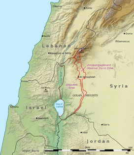
| Location | Golan Heights |
| Geology | |
| Mountain type | Volcano |
Mount Bental is one of Israel’s favourite mountain peaks to visit, partly due to the great panoramic views of the Golan and even Syria but also because Mount Bental was the site of a courageous battle fought during Israel’s war for the Golan. A short drive up, the mountain-top provides both scenic beauty and a glimpse back at the past – with bunkers open to visitors.
Mount Bental can be found in the middle of the Golan Heights, towards the Syrian border. The mountain is frequently visited and has a fun cafe way up top – Coffee Anan (a pun on both the UN leader and the Hebrew for “Coffee of the Clouds”). Coffee, tea and cakes with a view! The old army bunkers are open to the public, most of them have been completely cleared out but old beds and batteries can still be seen – and bumped into if walking without the aid of a flashlight. In a small room within the bunker, the tale of the battle can be read from signs on the wall. Maps help to understand the logistics and geography of the battle. When emerging from the bunker, a video binocular can be operate for a small fee to see the Israeli-Syrian frontier and the old battlefield now covered over with fields of grain and produce.
The battle itself was held during the Yom Kippur War in 1973. It was one of the largest tank battles ever and was miraculously won by the Israelis with their small force of 160 tanks. The Syrians attacked with 1,500 tanks and 1,000 artillery pieces to be slowly mowed down by the much, much smaller Israeli force. The Israeli army suffered large casualties as well and by the time the battle was over, only 7 Israeli tanks were operational. After 900 of the Syrian tanks were destroyed, the Syrians turned and fled, leaving the land for the victorious Israelis. Today, to remember the bloody battle, the valley below the mountain, reaching to Mount Hermon, is called the Valley of Tears.

Mount Bental – Mountain-top bunker
Recently repaved and fixed up for the tourism industry, Mount Bental also boasts a metal sculpture garden by Dutch artist Joop de Jong.
Visiting Mount Bental
Entrance to the site is free of charge and the site is open all day, every day.
Mount Bental (Arabic: جبل بنطل , جبل الغرام / ALA-LC: Jabal al-Gharam / "Mountain of Lust" "Jabal Bental"; Hebrew: הר בנטל, Har Bental, "Mount Bental") is a dormant volcano in the North-Eastern part of the Golan Heights, It extends to an elevation of 1,171 Meters above sea level.
Geology
The mountain is a part of a chain of dormant volcanic mountains spanning along the eastern part of the Golan Heights starting from Mount Ram in the north and ending on Tal Saki in the south, it is the northern neighbor of Mount Avital which shares the same volcanic magma source with it. Mount Bental was formed in a volcanic eruption which formed a scoria volcanic cone, the magma which tried to erupt from Mount Avital's top could not do so and the pressure lead to an eruption of the western side of Mount Avital and of Mount Bental.
The Mountain
Mount Bental is covered with Quercus calliprinos trees and on its top there is an IDF stronghold which was built on an older Syrian stronghold which is an attraction point for visitors. The mountain top has a good view of the Syrian lands, Mount Hermon and the Golan Heights.
Merom Golan is located at the bottom of the volcanic crater.[1]


No comments:
Post a Comment